mardi 5 mai 2009

Miyajima, Japan


Itsukushima (厳島 ?) is an island in the Inland Sea of Japan. It is popularly known as Miyajima (宮島 ?), the Shrine Island. Itsukushima is part of the city of Hatsukaichi in Hiroshima Prefecture. The island was the town of Miyajima prior to the 2005 merger with Hatsukaichi.


Itsukushima is famous for the Itsukushima Shrine, a UNESCO World Heritage Site. According to records, the shrine was established in the time of Empress Suiko. The warrior-courtier Taira no Kiyomori gave the shrine its present form. In 1555, Mōri Motonari defeated Sue Harukata at the Battle of Miyajima. Toyotomi Hideyoshi built a large building, the Senjō-kaku, on a hill above the shrine.


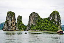
The island of Itsukushima, including the waters around it (part of Seto Inland Sea), and are within Setonaikai National Park.

Itsukushima is mountainous and sparsely settled. It does have an elementary school and a middle school. There are no traffic signals.

Frequent ferry services, operated by JR West (JR Miyajima ferry) and by Miyajima Matsudai Tourist Ship, carry traffic between the island and the mainland. The trip takes about ten minutes. There is an hourly express passenger ferry to Hiroshima harbour.

Miyajima's maple trees are renowned throughout Japan, and blanket the island in crimson in the autumn. Momiji manju, pastries filled with azuki jam or custard, are popular souvenirs, and carry maple-leaf emblems. Many other varieties such as chocolate and cheese are also available. Because the island is seen as sacred, trees may not be cut for lumber. Deer and monkeys roam freely. Deer are thought of as sacred in the native Shinto religion because they are considered messengers of the gods.


A style of wooden spoon used to serve cooked rice, without impairing the taste, is said to have been invented by a monk who lived on the island. This style of spoon is a popular souvenir and there are some outsized examples around the shopping district.

The peak of Mount Misen, at 535 m, is the highest point on the island. Miyajima Ropeway carries visitors to within a 30-minute hike to the top. There are several sites related to the historical Buddhist priest Kōbō Daishi near the top. The island also contains the Miyajima Natural Botanical Garden.

Source: Wikipedia


samedi 2 mai 2009

Gion, Kyoto


Gion (祇園) is a district of Kyoto, Japan, originally developed in the Middle Ages, in front of Yasaka Shrine. The district was built to accommodate the needs of travelers and visitors to the shrine. It eventually evolved to become one of the most exclusive and well-known geisha districts in all of Japan.


The geisha in the Gion district do not refer to themselves as geisha; instead, Gion geisha use the local term ''geiko''. While the term geisha means "artist" or "person of the arts", the more direct term geiko means essentially "a child of the arts" or "a woman of art."


This neighborhood in Kyoto has two hanamachi (geiko communities) : Gion Kōbu (祇園甲部) and Gion Higashi (祇園東). Despite the considerable decline in the number of geisha in Gion in the last one hundred years, it is still famous for the preservation of forms of traditional architecture and entertainment.


A Shrine

Part of this district has been declared a national historical preservation district. Recently, the City of Kyoto completed a project to restore the streets of Gion, which included such plans as moving all overhead utilities underground as part of the ongoing effort to preserve the original beauty of Gion.


Gion remains dotted with old-style Japanese houses called machiya, which roughly translated means "townhouse", some of which are ochaya or "tea houses." These are traditional establishments where the patrons of Gion -- from the samurai of old to modern-day businessmen -- have been entertained by geiko in an exclusive manner for centuries.


What on Geishas sleep!

Geisha were trained to sleep with their necks on small supports (takamakura), instead of pillows, so they could keep their hairstyle perfect. To reinforce this habit, their mentors would pour rice around the base of the support. If the geisha's head rolled off the support while she slept, rice would stick to the pomade in her hair. The geisha would thus have to repeat the tiresome process of having her hair elaborately styled. Without this happening, a geisha will have her hair styled every week or so.

祇園祭 Gion Matsuri (The Gion Festival)

Gion is also known for its Gion Festival (祇園祭 ,Gion Matsuri) that takes place annually in Kyoto. It is one of the most famous festivals in Japan. It spans the entire month of July and is crowned by a parade, the Yamaboko Junkō (山鉾巡行 ?) on July 17.


During the Gion Festival

Kyoto's downtown area is reserved for pedestrian traffic on the three nights leading up to the massive parade. These nights are known as yoiyama (宵山) on July 16th, yoiyoiyama (宵々山) on July 15th, and yoiyoiyoiyama (宵々々山) on July 14th. The streets are lined with night stalls selling food such as yakitori (barbecued chicken skewers), taiyaki, takoyaki, okonomiyaki, traditional Japanese sweets, and many other culinary delights. Many girls dressed in yukata (summer kimono) walk around the area, carrying with them traditional purses and paper fans.


During the Gion Festival

During the yoiyama eves leading up to the parade, some private houses in the old kimono merchant district open their entryways to the public, exhibiting valuable family heirlooms, in a custom known as the Byōbu Matsuri, or Folding Screen Festival. This is a precious opportunity to visit and observe traditional Japanese residences of Kyoto.


vendredi 1 mai 2009

Hạ Long Bay, Vietnam


Hạ Long Bay (literally: Descending Dragon bay; Vietnamese: Vịnh Hạ Long) is a UNESCO World Heritage site located in Quảng Ninh province, Vietnam. The bay features thousands of limestone karsts and isles in various sizes and shapes.

Ha Long Bay is located in northeastern Vietnam, from E106°56' to E107°37' and from N20°43' to N21°09'. The bay stretches from Yên Hưng district, past Hạ Long city, Cẩm Phả town to Vân Đồn district, bordered on the south and southeast by the Gulf of Tonkin, on the north by China and on the west and southwest by Cát Bà island. The bay has a 120 kilometre long coastline and is approximately 1,553 square kilometres in size with about 2000 islets. The area designated by UNESCO as the World Natural Heritage Site includes 434 km² with 775 islets, of which the core zone is delimited by 69 points: Đầu Gỗ island on the west, Ba Hầm lake on the south and Cống Tây island on the east. The protected area is from the Cái Dăm petrol store to Quang Hanh commune, Cẩm Phả town and the surrounding giants zone.

Local legend has it that long ago, when the Vietnamese were fighting Chinese invaders, the gods sent a family of dragons to help defend the land. This family of dragons began spitting out jewels and jade. These jewels turned into the islands and islets dotting the bay, linking together to form a great wall against the invaders. The people kept their land safe and formed what later became the country of Vietnam. After that, dragons were interested in peaceful sightseeing of the Earth and decided to live here then. The place where Mother Dragon flew down was named Hạ Long, the place where the dragon children attended upon their mother was called Bái Tử Long island (Bái: attend upon, Tử: children, Long: dragon), and the place where the dragon children wriggled their tails violently was called Bạch Long Vỹ island (Bạch: white- colour of the foam made when Children Dragon wriggle, Long: dragon, Vỹ: tail).


Source: Wikipedia


Hué


Thien Mu pagoda

Huế is the capital city of Thừa Thiên - Huế province, Vietnam. Between 1802 and 1945, it was the imperial capital of the Nguyễn Dynasty. As such, it is well known for its monuments and architecture. Its population stands at about 340,000 people.


Forbidden city and Huong river

Huế originally rose to prominence as the capital of the Nguyễn Lords, a feudal dynasty which dominated much of southern Vietnam from the 17th to the 19th century. In 1775 when Trinh Sam captured it, it was known as Phú Xuân. In 1802, Nguyễn Phúc Ánh (later Emperor Gia Long) succeeded in establishing his control over the whole of Vietnam, thereby making Huế the national capital.


Huế was the national capital until 1945, when Emperor Bảo Đại abdicated and a Communist government was established in Hà Nội (Hanoi), in the north. While Bảo Đại was briefly proclaimed "Head of State" with the help of the returning French colonialists in 1949 (although not with recognition from the Communists and the full acceptance of the Vietnamese people), his new capital was Sài Gòn (Saigon), in the south.


In the Vietnam War, Huế's central position placed it very near the border between North Vietnam and South Vietnam. The city was located in the South. In the Tết Offensive of 1968, during the Battle of Hue, the city suffered considerable damage not only to its physical features, but its reputation as well, most of it from American firepower and bombings on the historical buildings as well as the now infamous massacre at Huế committed by the Communist forces. After the war's conclusion, many of the historic features of Huế were neglected, being seen by the victorious regime and some other Vietnamese as "relics from the feudal regime", but there has since been a change of policy, and some parts of the historic city have been restored.

The city is located in central Vietnam on the banks of the Sông Hương (Hương River), just a few miles inland from the Biển Đông. It is about 700 km (438 mi.) south of the national capital of Hanoi and about 1100 km (690 mi.) north of Hồ Chí Minh City, the country's largest city formerly known as Saigon.


The Forbidden City

The climate is hot and generally wet (Köppen Af). Because of the angle of the central coast of Vietnam to the prevailing winds, however, Huế, like Chennai in India, receives most of its rainfall during the northeast monsoon between October and December. It is driest around March and April, but rain may still fall. The average annual rainfall of 3,000 millimetres (120 in) makes Huế one of the very wettest of Asian cities.

Huế is perhaps best known for its historic monuments, which have earned it a place in the UNESCO's World Heritage Sites. The seat of the Nguyen emperors was in the Citadel, which occupies a large, walled area on the north side of the river. Inside the citadel was a forbidden city where only the concubines, emperors, and those close enough to them were granted access, the punishment for trespassing being death. Today, little of the forbidden city remains, though reconstruction efforts are in progress to maintain it as a tourist attraction as a view of the history of Huế.


The citadel in Hue with flag tower

Roughly along the Perfume River from Huế lie myriad other monuments, including the tombs of several emperors such as Minh Mang, Khai Dinh, Tu Duc, and others. Also notable is the Thien Mu Pagoda, located not far from the city centre along the river, the largest pagoda in Huế and chosen as the official symbol of the city.


Huong river


Ueno and the Ueno Park

Ueno

I found Ueno very peaceful even if very poor. The homeless people are so attaching and nice there! I would definitely go back there only to make some photography!


Homeless person in the Ueno Park

Ueno (上野) is a district in Tokyo's Taitō Ward, best known as the home of Ueno Station and Ueno Park. Ueno is also home to some of Tokyo's finest cultural sites, including the Tokyo National Museum, the National Museum of Western Art, and the National Science Museum, as well as a major public concert hall. Many Buddhist temples are in the area, including the Bentendo temple dedicated to goddess Benzaiten, on an island in Shinobazu Pond. The Kan'ei-ji, a major temple of the Tokugawa shoguns, stood in this area, and its pagoda is now within the grounds of the Ueno Zoo. Nearby is the Ueno Tōshōgū, a Shinto shrine to Tokugawa Ieyasu. Near the Tokyo National Museum there's The International Library of Children's Literature. Just south of the station is the Ameyayokocho, a street market district that evolved out of an open-air black market that sprung up after World War II. Just east is the motorcycle specialty district, with English-speaking staff available in some stores.

Homeless person in the Ueno Park

Ueno is in the historical Shitamachi, literally "down-town" district of Japan, a working class area rather than where the aristocrats and rich merchants lived. Today the immediate area, due to its close proximity to a major transportation hub, retains high land value but just a short walk away to the east or north reveals some of the less glitzy architecture of Tokyo.

A dancer in the Ueno Park

JustifierUeno Park and Ueno Station are also home to a large percentage of Tokyo's homeless population. Though nearly invisible in other parts of Tokyo, the homeless population in Ueno can be found sleeping or communing in large numbers around the "ike" (ponds) of this district.

Homeless person in the Ueno Park

Source: Wikipedia

jeudi 30 avril 2009

Koh Phangan


Ko Pha Ngan (or Koh Phangan, Thai: เกาะพะงัน) is an island in the Gulf of Thailand in South East Thailand. It is famous for its full moon party at Haad Rin Beach and as a backpackers destination. Ko Pha Ngan has two sister islands: the larger Ko Samui to the south and the smaller Ko Tao to the north.


The Bronze Drum of Dongson Culture (500BC - 100BC) that was found on Ko Samui in 1977 is evidence that there were settlements of people on Ko Samui, Ko Pha Ngan, and their islets from more than two thousand years ago. Some historians and archaeologists believe that the first group who migrated to Ko Pha Ngan were the Muslim sea Gypsies (Pygmy, Semung, and Proto-Malay) who travelled by boat from the Malay Peninsula. However, nowadays there are few Muslims who live on the island. The name of Ko Pha Ngan comes from the word 'Ngan', the southern dialect meaning 'sand bar', for there are many sand bars offshore around the island. Ko Pha Ngan has been a long time favorite of past kings of Thailand. Specifically Rama V, or Chulalongkorn visited Ko Pha Ngan 14 times during his reign.


As a natural paradise island in the Southern Gulf of Thailand, Ko Pha Ngan is often seen as a getaway retreat, where one may go relaxing on the many quiet deserted beaches including the beautiful Chalok lam Bay, Ban Tai, Ban Khai, Haad Yao, Haad Salat, Haad Son and the Mae Haed beaches. There are many activities in which to participate including snorkeling and learning to dive at the distinctive island of Ko Ma, trekking in the footsteps of Thai Royalty at Than Sadet National Park steeped in history and culture, or seeking adventure in the nearby Ang Thong archipelago composed of over 40 islands endowed with pristine beaches, natural caves and the tranquil Tha Laem Nai. Ko Pha Ngan has over 250 resorts to choose from, ranging from the budget 80 baht a night beach hut without private toilet to luxury air-conditioned accommodation with private swimming pool.


It's the simple beach life which continues to attract visitors each year along with the island's reputation for full moon parties and a hedonistic approach to life. The backpackers, budget tourists and aging hippies are beginning to give way to families and more mainstream tourists as all the beaches are fully developed. The full moon party consists of tens of thousands in high season - all on the beach. Revelers from all over the world still flock to the world's biggest beach party every month. The music from the multiple sound systems is made up mostly of electronic styles such as Psytrance, house, techno and drum & bass and a predominantly youthful crowd dance 'til dawn on party nights. It has been reported that western tourists have been victims of unprovoked assaults by gangs on a number of occasions, particularly around the time of the full moon parties late at night in the vicinity of bars in Haad Rin.[3] Other events such as the Half Moon Party and Black Moon Party also attract large crowds. Despite the special titles the events on the beach are identical every single night. However, it is still possible to visit the island and avoid the full moon party altogether, with dozens of quiet, secluded resorts and beach huts dotted all over the island for a variety of prices. Many of the more costly resorts offer such facilities as daily yoga, yoga teachers' training, meditation, a variety of healing, healthy & natural therapies, spa massage& pampering services and herbal steam rooms.


Source: Wikipedia

Koh Tao

Ko Tao is an amazing island in Thailand, located near the eastern shore of the Gulf of Thailand. It covers an area of about 21 km².


The economy of the island is almost exclusively centered around tourism, especially scuba diving.

The Island is also known for his numerous parties, even if it doesn't have the same reputation than Koh Phangan.

Ko Tao was named by its first settlers for the island's turtle-like geographic shape. The Island has become increasingly popular especially in the mid-20's backpacker crowd in search of relatively inexpensive scuba diving certification. This is the place to go for diving, but please take care of the fragile environment!

Source: Wikipedia